
Sub-Area Risk Assessments

Vail
Vail is a 4.6 square mile high density development of 5000 full time residents, 5000 additional part time residents and millions of annual visitors. The community is situated along a 10 mile stretch of interstate 70 and extends approximately ¼ mile north and south of the Interstate. The community is completely surrounded by the White River National Forest and is home to Vail Mountain, one of the largest economic centers of the county. Due to the space constraints of the valley nearly all structures within the community are built within 30 feet of the nearest structure. The valley is surrounded by steep slopes and dense vegetation leading to high likelihood of high severity fire. Lower and Middle Gore Creek have known areas of geologic instability and risk for post fire flooding and debris flow is high. If a large- scale evacuation was necessary I-70 is the only route out of the community and will likely have significant congestion on the routes leading to the interstate.
RISK:
The overall risk rating to the Vail area is HIGH. Topographic feathers pose a challenge for fire suppression and the density of structures lead to a high likelihood of structure to structure ignitions if fire enters into the community. Concerns surround evacuation routes capacity as well as large guest populations during high fire potential times. While burn probability is lower in the area, fire intensity is very high which increases the risks of significant post fire impacts to communities and critical infrastructure.
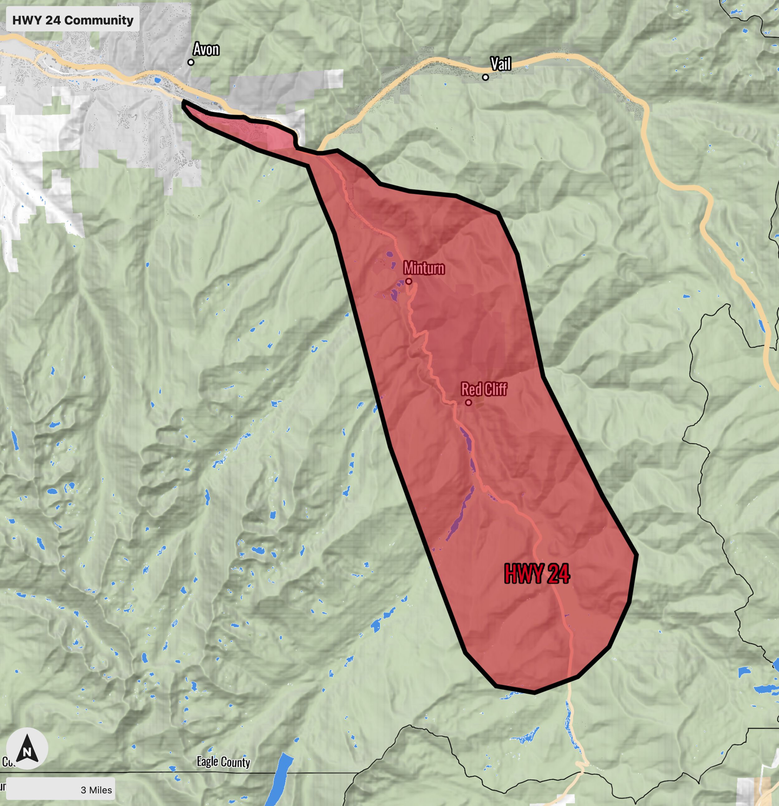
Highway 24
The Highway 24 area encompasses the communities of Eagle-Vail, Minturn, Red Cliff, and scattered development on Tennessee Pass. Eagle-Vail has approximately 4,000 residents with about 850 structures, and Minturn is home for 1,140 people with over 500 commercial and residential structures.Along the Highway 24 corridor are the historic towns of Minturn and Redcliff, as well as scattered development on Tennessee Pass with residential and commercial structures. The Eagle River flows parallel to Highway 24 through Minturn. Whiskey Creek flows into the Eagle River near the intersection of Highway 6 and Highway 24. The water treatment plant in Minturn has its intake on Cross Creek.
Vegetation at lower elevations in Whiskey Creek and Minturn is made up of juniper in the overstory with grasses, sagebrush, and serviceberry in the understory. At higher elevations, lodgepole pine and aspen become the predominant overstory species, with thick serviceberry in the understory. Much of the lodgepole has been killed by the Mountain Pine Beetle, with some areas experiencing 80% tree mortality. Due to suppression of the natural fire regime, the juniper is growing extremely dense, and is drought stressed. Sagebrush in the area has grown to be 2-3 feet tall and decadent.
RISK:
The overall risk rating to the HWY 24 area is EXTREME. Topographic feathers pose a significant threat to life and property. Concerns surround evacuation routes and structure to structure fire movement in the communities of EagleVail, Minturn, and Red Cliff. There are also concerns about the outlying communities that surround the HWY 24 Corridor. Special attention should be given to strengthening evacuation routes and areas where movement of traffic will slow (e.g. Battle Mountain Pass).
Note: High risk areas also surround the Eagle Mine, Gilman and Camp Hail for hazardous materials and confirmed unexploded ordnance.
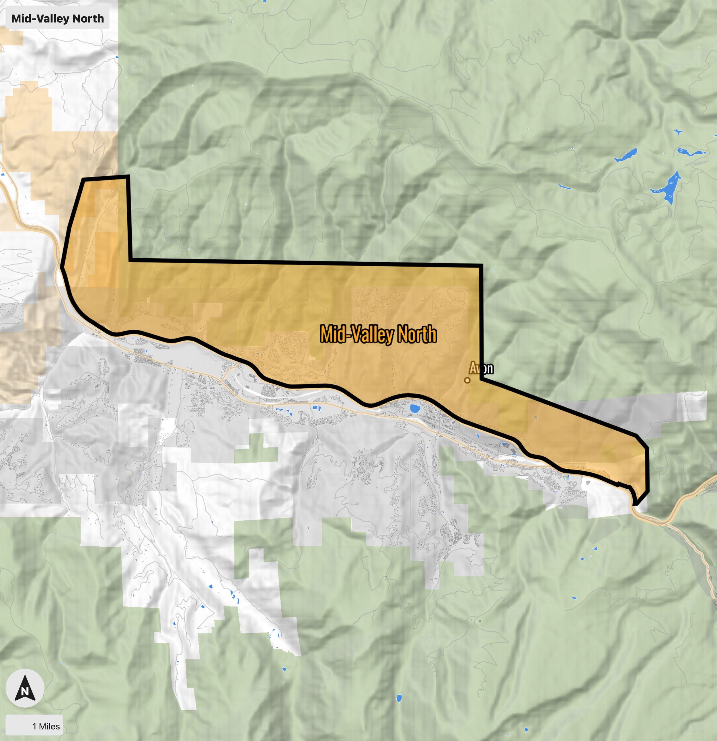
Mid-Valley North
Mid-Valley North encompasses areas in Avon and Edwards north of I-70, including the Cordillera Valley Club, Singletree, Wildwood, Wildridge, and Mountain Star sub-divisions, totaling 1,730 structures. There are approximately over 9,000 people in Edwards and 6,500 people in Avon. Vegetation in this area is primarily made up of pinon pine and juniper in the overstory, with grasses and sagebrush in the understory. Douglas fir and aspen are present in drainages with sagebrush and grass in the understory. June Creek and Berry Creek flow through the Singletree and Cordillera Valley Club areas, and eventually into the Eagle River. Suppression of the natural fire regime has led to extremely dense juniper and sagebrush near values at-risk. Vegetation throughout the area is drought stressed. Due to an Ips beetle outbreak, approximately 50% of the pinon pine has been killed.
Wildridge, Mountain Star, Cordillera Valley, and Singletree have power lines and other energy infrastructure running through them. Should these areas get directly impacted by wildfire, the ramifications could be felt by the residents in Avon, as well as the entire county for months to years after the event. Due to the steep terrain and dense, flashy fuels, fast and intense fire growth is possible that could overwhelm initial response.
RISK:
The overall risk to life and property in Mid-Valley North is HIGH. The primary factors leading to the high risk rating are the fragile evacuation routes of Mountain Star, Wildridge, Singletree, Cordillera Valley Club, and Red Canyon Estates. A fire ignition of Interstate 70 could quickly compromise evacuation routes in the area. Suppression difficulty is complex due to the sleep terrain in most areas. Special attention should be given to projects that support the protection of the communities.
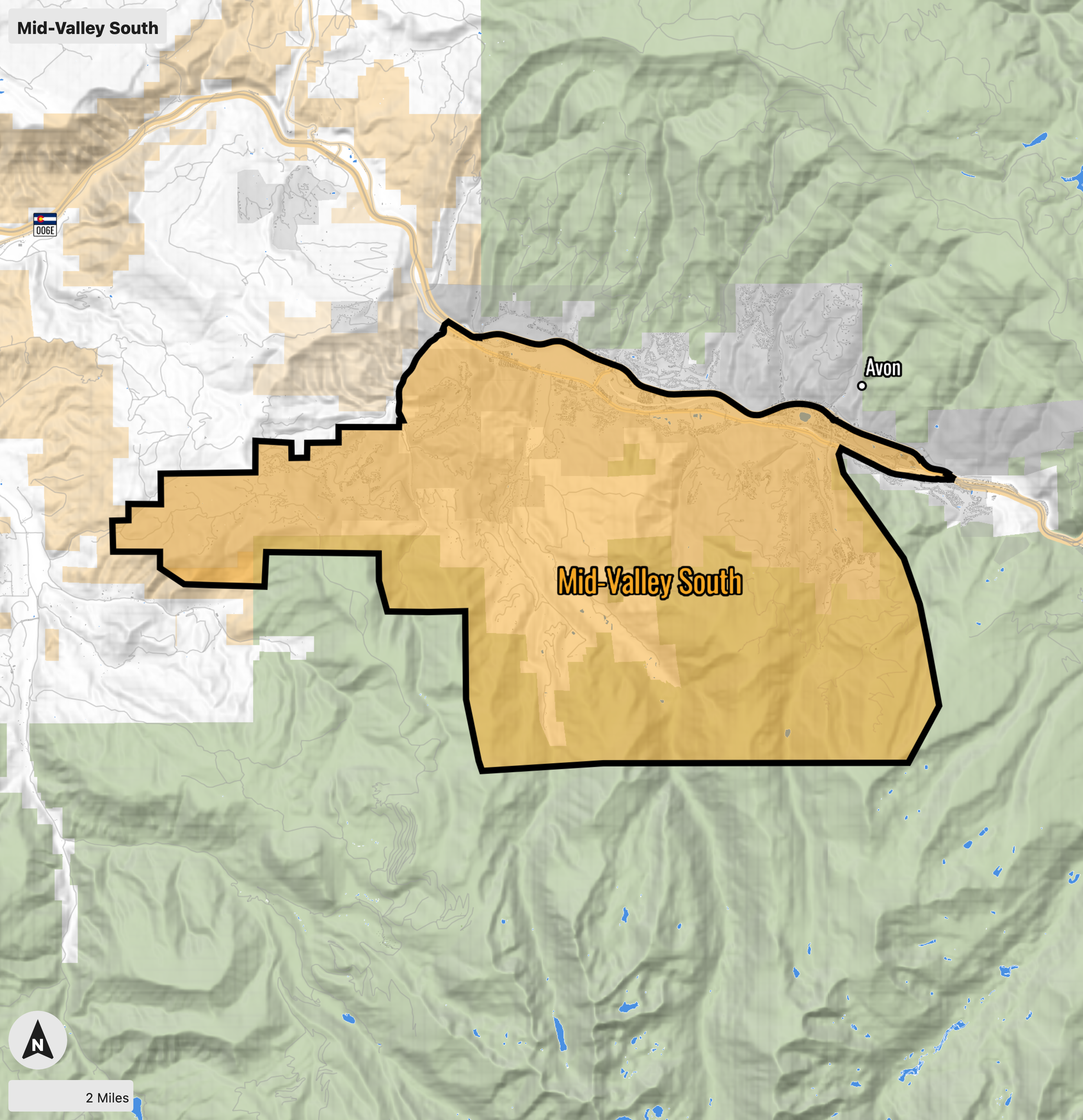
Mid-Valley South
Mid-Valley South encompasses areas in Avon and Edwards south of I-70, including Lake Creak, Creamery Ranch, Homestead, and the Cordillera, Arrowhead, Bachelor Gulch, and Beaver Creek Metro Districts. There are over 4321 structures, with approximately over 9,000 people in Edwards and 6,500 people in Avon. Vegetation in this area is primarily made up of lodgepole pine, Douglas fir, and aspen in the overstory with grasses, sagebrush, and dense serviceberry in the understory. Due to suppression of the natural fire regime, the serviceberry and aspen are growing extremely densely.A mountain pine beetle outbreak has resulted in approximately 50% of the lodgepole pine in the area being killed.
The majority of homes and businesses are located within three subdivisions on the south side of Avon: Arrowhead, Bachelor Gulch, and Beaver Creek. These areas contain some of the highest value real estate in Eagle County, as well as a ski resort and commercial areas that provide thousands of jobs to residents throughout the county. Should these areas get directly impacted by wildfire, the ramifications will be felt by the residents in Avon, and could be felt by businesses and workers throughout the entire county (and those that commute from outside the county to work in the resorts and commercial areas).
RISK:
The overall risk to Mid-Valley South is HIGH. The primary risk factor is one way in and one-way-out communities. Each drainage has no options of evacuation to the south other than one area on the most western boundary of Cordillera. Although the risk of a fast moving fire is lower than Mid-Valley South the burn severity is much higher. With the fuel types in these communities a well established fire will be difficult to suppress. The Bellyache ridge is the breaking point of fire severity and burn probability, meaning with the high probability of fire moving from the west and the Brush Creek Drainage into the heavy fuel types to the East of Bellyache Ridge a severe long lasting fire carries a HIGH risk of suppression difficulty and long term impact.

Wolcott
Encompasses the area around Wolcott, including Red Sky Ranch, Diamond Star, Bellyache Ridge, and public and private land along Highway 131 to McCoy (Horse Mountain Ranch, Muddy Pass, Milk Creek, and Alkali Creek Roads). Vegetation in the area is primarily made up of pinon pine and juniper in the overstory, with grasses and sagebrush in the understory. Red Sky Ranch and Bellyache Ridge have very sparse timber, with the vast majority being decadent sagebrush. Diamond Star has serviceberry, and rabbitbrush mixed in with the sagebrush in the understory, and stands of Douglas Fir at higher elevations.
Sagebrush in Red Sky Ranch and Bellyache Ridge is growing two to four feet tall, decadent, and extremely dense and continuous over steep terrain. Due to suppression of the natural fire regime, the juniper in Diamond Star Ranch is extremely dense, and drought stressed. An Ips beetle outbreak has resulted in approximately 50% of the pinon pine being killed.
Bellyache Ridge, Red Sky Ranch and Diamond Star Ranch are located in steep terrain with flashy fuels, immediately adjacent to BLM land with further dense, flashy fuels. Should a significant wildfire get established in these areas, the ensuing erosion and pollution of the Eagle River downstream could affect the Town of Eagle and Eagle County for years to come. Additionally, due to the difficult terrain and fuels, fires in these areas could overwhelm initial response. While housing density is low in the immediate vicinity, fire could rapidly reach more populated areas in Eagle or Edwards before firefighters are able to get a foothold.
RISK:
Risk to the Wolcott area is HIGH. The communities of Diamond Star, Red Sky Ranch, Bellyache Ridge, and Horse Mountain Ranch carry the highest risk to life and property due to suppression difficulty along with fuel types along the southern boundaries. The Bellyache ridge is the breaking point of fire severity and burn probability, meaning with the high probability of fire moving from the west and the Brush Creek Drainage into the heavy fuel types to the East of Bellyache Ridge a severe long lasting fire carries a HIGH risk of suppression difficulty and long term impact. A High Risk is also being assigned to the communities of Bond, McCoy, Rancho Del Rio and the sub communities along HWY 131. Response time is the primary factor of concern in these communities.
Note: The Wolcott area has more fires per year than any other unit in the Eagle Valley Wildland response area.

Eagle
This area encompasses Eagle and outlying areas, including the Brush Creek Valley, Eagle Ranch, Eby Creek, Upper Kaibab, Frost Creek, the Salt Creek and Bruce Creek drainages, and Sylvan Lake State Park. More than 7,500 people live in Eagle. There are roughly 2,100 homes throughout the area, as well as power lines, and I-70 running through the town.
Vegetation in the area is primatrily made up of pinon pine and juniper in the overstory, with grasses and sagebrush in the understory. The Bruce Creek drainage consists of a pinon-juniper overstory with sagebrush, grasses, serviceberry, and rabbitbrush in the understory, with Douglas Fir and quaking aspen at higher elevations. In Bruce Creek, Gambel oak is prolific in the understory, growing over 10 feet tall and nearly impenetrable in areas. Due to suppression of the natural fire regime, juniper is growing extremely densely and is drought stressed. An Ips beetle outbreak has resulted in approximately 50% of the pinon pine being killed.
Should a significant wildfire become established in these areas, the ensuing erosion and pollution of the Eagle River downstream could affect the Town of Eagle and Eagle County for years to come. The Eagle area is heavily used for recreation and is immediately adjacent to I-70, making it an extremely fire prone area. The Eagle Ranch neighborhood is immediately adjacent to BLM lands with dense, flashy fuels.
RISK:
The overall risk to the Eagle Area is MODERATE. Since most of the Eagle area carries significantly less topographic concerts than many of the other locations in Eagle County the Suppression Difficulty is much less than other adjacent areas. Note that Moderate concern is elevated due to light flashy fuels in most areas and the high likelihood of wildfire in the area.
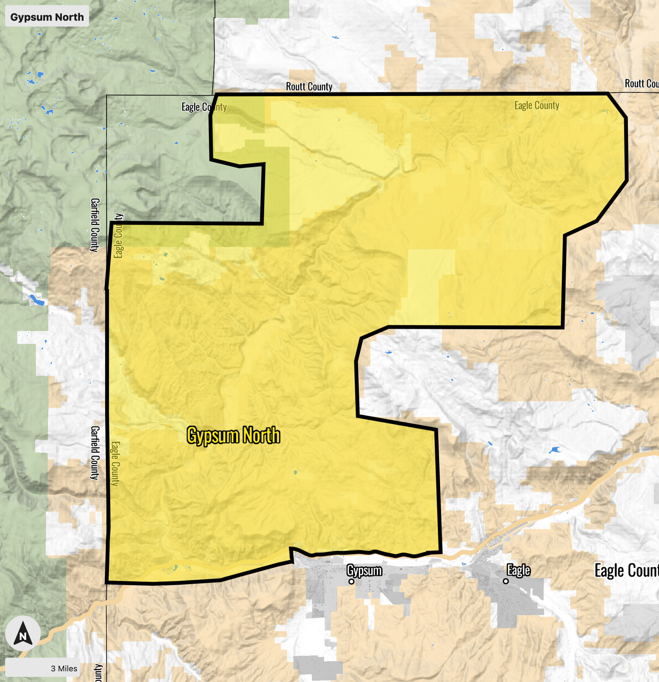
Gypsum North
The Gypsum North area encompasses private and federally managed lands in the areas off the Colorado River Road and Trail Gulch Road, and the Burns, Sweetwater, and Derby Mesa communities. It is sparsely populated, with approximately 500 known structures. Most of the land ownership is managed by the Upper Colorado River District Bureau of Land Management, with some private ranches scattered throughout. Most roads are unpaved and subject to being washed out by flash flooding throughout the summer. Cell phone coverage is minimal and there are areas without radio coverage.
Vegetation consists primarily of sagebrush, pinon pine, juniper, and native grasses, with some areas of aspen and mixed conifer forests at higher elevations. In most areas, suppression of the natural fire regime has caused sagebrush to become decadent, and juniper encroachment has increased the fuel loading to far beyond historical norms. The Colorado River sees significant recreation activity from fishing and rafting, 4 wheeling, hunting, and recreational shooting. All of these activities bring the hazard of human-caused wildfires, exacerbating the hazard caused by frequent lightning ignitions in the area.
RISK:
The Overall risk to Gypsum North is MODERATE. Gypsum North carries a high likelihood of wildfire. However the location of most homes in the area are near moderate Suppression Difficulty and potential control feature (e.g. Colorado River or irrigated fields). The topographic feature of the Colorado River Road poses some concern but not enough to drive a high rating.

Gypsum South
The Gypsum South area encompasses Gypsum, the Eagle County Airport, Airport Industrial Park, Chatfield Corners, Brightwater, Spring Valley, and public and private lands in the Gypsum Creek drainage. Gypsum is home for 8,040 people. About 400 homes are in the Spring Valley Neighborhood.
Vegetation consists primarily of pinon pine and juniper in the overstory, with grasses and sagebrush in the understory. Due to suppression of the natural fire regime, the juniper is growing extremely densely and is drought stressed. An Ips beetle outbreak has killed about 50% of the pinon pine in the area. The area around Mosher Spring is in an ecological transition zone, where pinon pine and juniper are mixed with decadent aspen stands and lodgepole pine. Engelmann spruce and subalpine fir with heavy dead-and-down in the higher elevation areas of the units. Grasses and sagebrush mix with serviceberry, rabbit brush, and other woody shrubs in the understory.
Mosher Spring is a historic homestead that supplies the town of Gypsum with drinking water after it passes through the Mosher Water Treatment plant. Should these areas get directly impacted, the ramifications could be felt by Gypsum and the entire county for decades. Both the drinking water resources and the Spring Valley neighborhood border Bureau of Land Management land that consists of flashy fuels (grass and decadent sagebrush) that can support fast and intense fire growth that could overwhelm initial response.
RISK:
The overall Risk to Gypsum South is HIGH due to the likelihood of fire moving into the communities of Red Hill and Sky Legend, both of which carry limited egress options. The Gypsum Creek Drainage also carries a high risk of long term effects as Gypsum Creek is the sole drinking water for Gypsum. The Gypsum South unit is also home to the Eagle County Regional Airport that is well within the spotting distance.

Roaring Fork
Roaring Fork Valley
Missouri Heights is a large residential area located on the mesa above El Jebel and the Highway 82 corridor. The area can be accessed from Highway 82 via El Jebel Road which becomes Upper Cattle Creek Road as it travels through Missouri Heights, or from Garfield County via County Road 102 which becomes Fender Lane. The primary vegetation in Missouri Heights is gambel-oak with a short grass and sagebrush understory, varying in coverage from uniformly dispersed sage to continuous stands of dense oak. Small sections of riparian vegetation are present near water sources and drainages, and a large tall grass meadow runs through the center of the community. Native and non-native ornamental grass, trees, and shrubs of various types can be found near home-sites as elements of residential landscaping. The Town of Basalt sits at the confluence of the Frying Pan River and Roaring Fork River, and is accessed from Highway 82 via Two Rivers Road. This historic railroad town is characterized by high structure density, and mature vegetation lining narrow streets. Many homes in Basalt have been there for generations. The WUI neighborhoods of Cedar Drive, Seven Castles, Big Hat, Peachblow and Ruedi Shores are found along the Frying Pan Road towards Ruedi Reservoir heading east. A wide variety of vegetation types are found in the planning area, including grass, sage, juniper, gambel-oak, serviceberry, aspen, lodgepole pine, and mixed conifer forests. North facing aspects in the Frying Pan River Valley have considerably higher fuel densities. Large transmission lines run below the community on its southern borders. Many homes in the area have wood siding, and most houses have conventional wood decks. Emergency responders will have to cross rated, and non-rated bridges over the Frying Pan River in order to access many homes in the community.
RISK:
The overall risk to the Roaring Fork planning area is HIGH. The Lake Christine Fire in 2018 burned through the Roaring Fork Valley, heavily impacting parts of Basalt and El Jebel. This large wildfire, which spread to almost 13,000 acres over 28 days, destroyed three residences and several outbuildings. The rolling hills and drainages, along with light, flashy fuels such as grass, sage and oak, will act to spread fire quickly throughout the area. Under extreme weather and fuel moisture conditions, fire intensity could become a serious issue making containment and control difficult to establish and maintain. Many homes in the community lack adequate defensible space, and ignition resistant construction.
